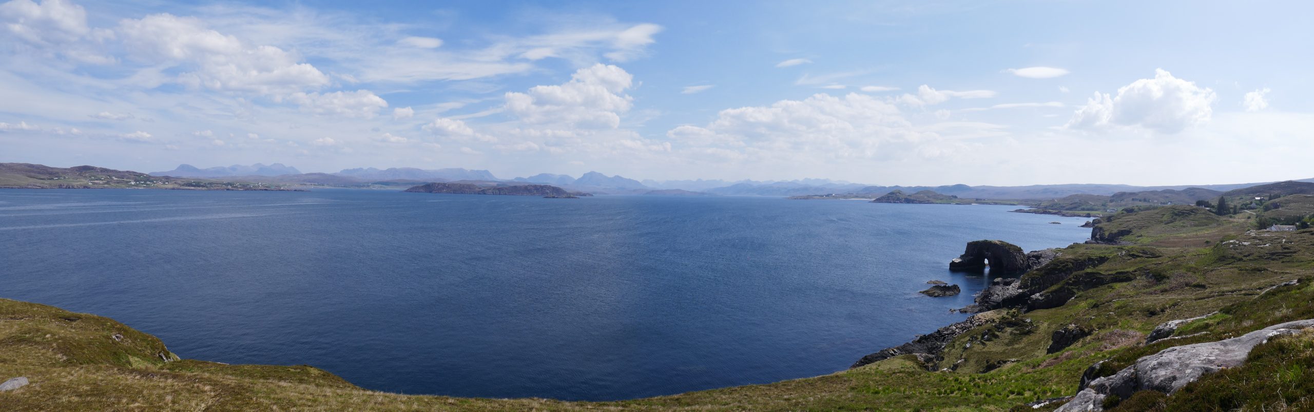
Unbeknown to me before my arrival, Loch Ewe has an unusual history. It is kind of the next bay south from Gruinard Bay, where I was staying. Calling it a bay is an injustice: over 10km long with a 2km wide entrance, it is something of a big natural harbour. Which is what it was press-ganged into use as during the second world war, when it was the gathering point for Arctic convoys.
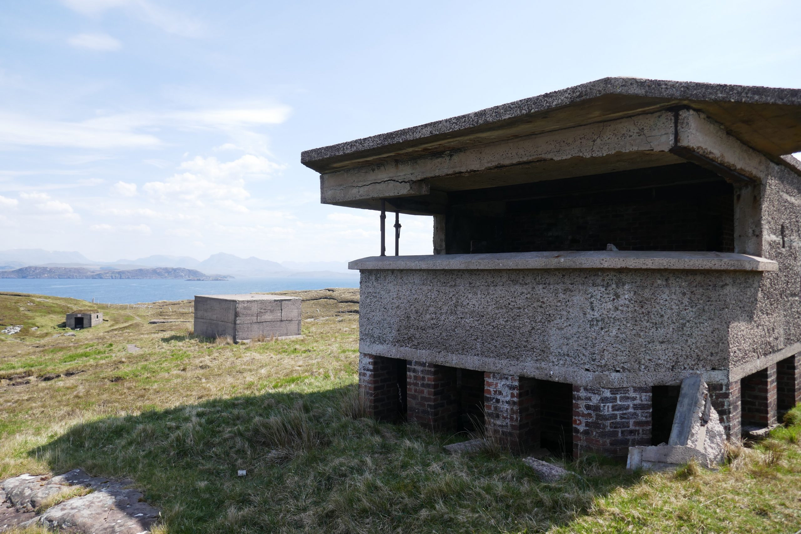
Having never been there, I was oblivious of this until I saw a sign for the Russian Arctic Convoy Museum in Aultbea. It was closed, but I still managed to learn something from the signs at viewpoints. And some residual features still remain. At the head of the peninsula on the western side some fortifications remain. Elsewhere, some places are still active, including a ship refuelling point south of Aultbea and a military base in Mellon Charles.
The latter turned out to be pertinent to today’s paddle. The most prominent feature of Loch Ewe is the Isle of Ewe. Roughly 3km by 1km, it lies a kilometre or so offshore from Aulbea and Mellon Charles. The southern two thirds appear to be open farmland, while the northern end has some crags. For me, this would give a more interesting paddle. So I concocted a plan to park at the pier in Mellon Charles, paddle the kilometre across and explore.
The best laid plans…
While it was a good plan in principle, it had two flaws in practice. The first was that the pier on the map sat within the military base. While it seemed deserted and security was a fence with keep out signs, launching off the pier clearly wasn’t going to happen. I parked in the cemetry car park next door to look for an accessible way to the shore. Which is when the second flaw in my plan became clear.
Although when I left Laide, which was on the opposite side of the peninsular, the wind was barely noticeable, in Mellon Charles is was blowing a hooley! Even worse, it would be blowing offshore. This meant that if I launched there then I would be paddling back into the wind when tired. This I didn’t fancy, so a plan B was needed.
I decided to check out the peninsular on the other side of the loch in case the wind was a very local thing, rather than just having picked up. Although only 3km as the crow flies, it was a 20 mile drive so, even if I couldn’t paddle, it would entertain me.
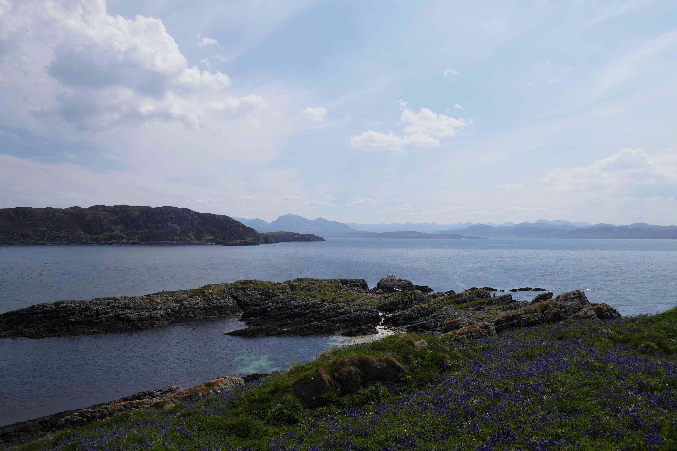
The drive was great. The weather was sunny and the views across the Loch from different angles were spectacular. My target was a large beach with a big P on the map. This turned out to be a sort of basic camping ground. A sprinkling of camper vans and cars had spread themselves over several acres of trimmed grass. Beyond sand and sea glistened in the sun. In short, it looked idyllic.
As got out of my car, I noticed someone in a wetsuit deflating their paddleboard, so in some sense I wasn’t alone. And the wind was weaker here, albeit still blowing more than I’d like. At least now it was onshore, so if I did feel it was too much it would be behind me getting back. Having swapped adaptors on my compressor after the preceding Sunday’s problems, preparation went smoothly too.
The paddle
It felt like a bit of a yomp as I carried the board and bag across the 300m across the grass and beach in my neoprene slippers. The beach was shallow, so I had to walk well into the water to launch my board. But there wasn’t much in the way of surf, so paddling out wasn’t too hard.
Once in the water, I realised the wind wasn’t straightforward. It had turned more northerly now. Paddling to the Isle of Ewe would have meant it would be sideways on for the whole trip. And the waves, which were slightly bigger than I would like, were coming from the same direction. Having realised this wouldn’t be fun, I changed targets. Just under a kilometre off the northern flank there was a small craggy island, Sgeir an Araig. Going for this would have me going more into the wind and waves. Plan C!
With the wind and waves coming from around 30o to my left, it was manageable. I tried to balance the effort required with avoiding fatigue. It felt like a continual ferry glide, though when I looked at the map afterwards the path was reasonably straight. Nevertheless, it was relatively slow progress. This turned out to be my longest paddle to date.
While I focussed on my target, I also hoped to see wildlife. Otters would be too much to hope for, but seals were known to inhabit the loch. After a short time I had to stop myself looking – every little shadow of a wave was turning into a seal’s head!
This is not the island you thought it was
Having imagined that I was going on a big adventure, heading where people rarely tread, I was surprised to see a couple of figures on the island as I approached it. They disappeared as I worked my way around some outcrops and landed in a little rocky bay on the leeward side of the island. A couple of terns sat atop a little peak above me, eyeing me with disdain. Trying to get closer for a photo only led to them fleeing.
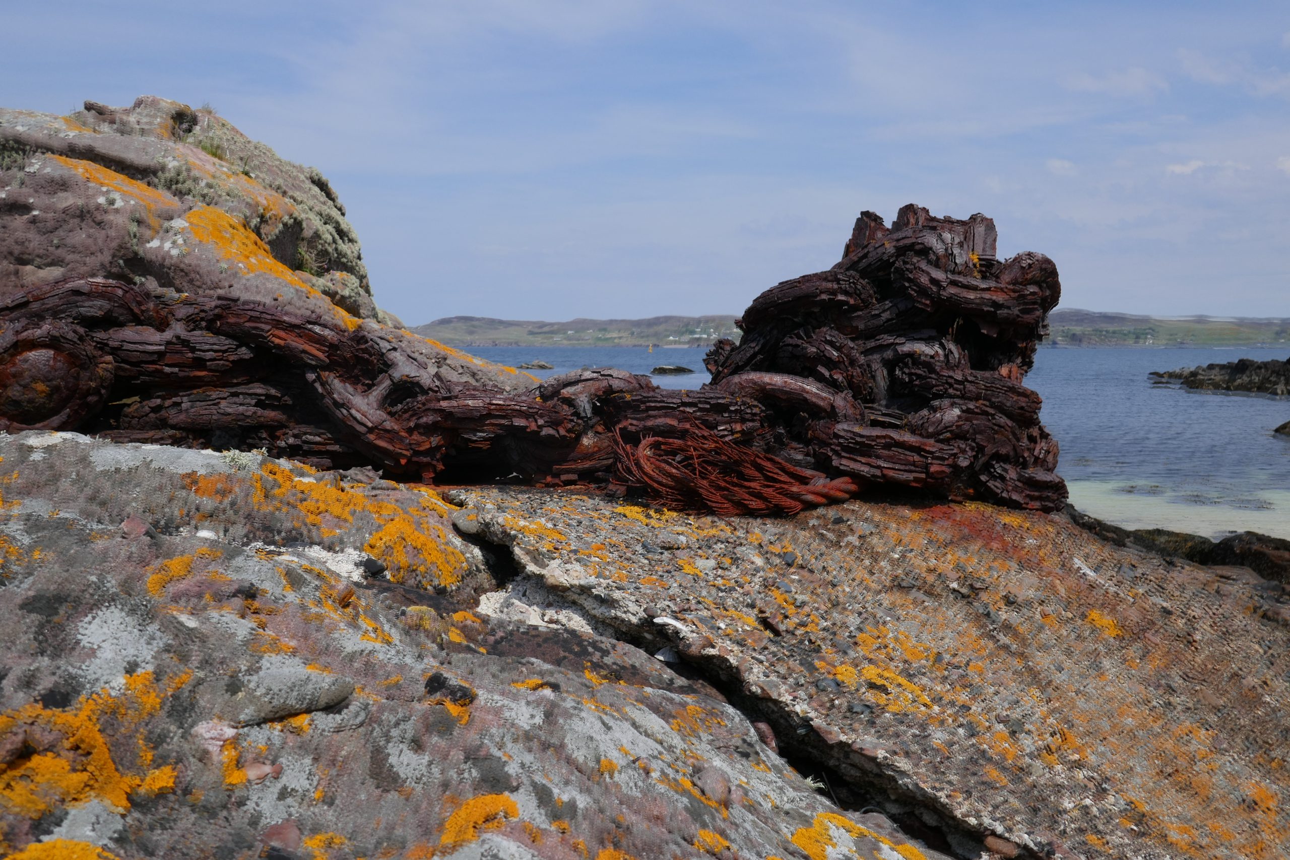
Across a rocky beach, I could see a trig point sitting on a grassy knoll above some crags. Climbing to the summit was inevitable, but had some small surprises along the way. Apart from some rubbish, there were a couple of rusted stanchions embedded in the rock. These turned out to be a mixture of stone and wood, one of which had rusted chain and wire still wrapped around it. The chain had large links, which made me think they were used to tie up ships. Although they seemed to be too onshore for that, I couldn’t figure out another use.
As I wandered across, I saw a canoe coming round the far side of the island and heading back towards the beach I had left from. Obviously they didn’t want company!
Finding a suitable gap in the small crag around the base, I realised that the lovely looking knoll, embellished with a spread of pretty blue flowers, was almost as much nettles as grass. Wearing shorts, I gingerly tried to stick to the latter and quickly reached the trig point. It was well worth the small effort, as the view from even a little bit up was fantastic.
A surprise while returning
I meandered back to my paddleboard, taking photographs and enjoying just being out there and knowing the wind would be at my back on the way home. I tried shooting the terns again, but they had decamped to one of the rocks offshore and proved elusive.
Heading back, I again started by trying to go across the wind so it would be more at my back later on. Whether it had picked up or I was getting tired, this seemed like hard work, so I gave up and ran with it at my back. I tried standing again. It felt better than a few days earlier, but still pretty unstable so soon went back to my knees. The waves were big enough to bother me too, though I was close to catching
But the wind was making it easier, even if I still had to work a bit to make sure I was blown into, and not past, the bay with the beach in. As I came into the bay I got a big surprise though – a small porpoise or dolphin popped out about 50m in front of me. I only saw it for a moment: it rolled over and disappeared in a second. I carefully looked at where its path would be if it continued but saw nothing more. It was only about a metre long, but it felt like a lovely thing to finish my paddle with.
I had to work a bit to stay away from the rocks on the point at the south side of the bay. But not too much, and soon I reached the beach again. I’d come in about twice as quickly as I had l gone out.
I was tired enough for the carry back to the car to feel an effort. It was well past lunchtime and I had only taken a single cereal bar with me. A nice couple who had parked near to me chatted as I packed up, but I was keen to get on my way and eat.
Coda
The cafe I had spotted in Poolewe was shut when I returned. But luckily I spotted a sign outside Poolewe and stopped there. Tremendous salmon salad! And strange eating in the snooker room cum library with old games on display! Big bonus end to the day 🙂
One thought on “A challenging paddleboard in Loch Ewe”